Arizona R&D Tax Credit Filing Instructions
To claim the Research and Development (R&D) tax credit in Arizona, businesses must first ensure their activities meet the criteria for Qualified Research Activities (QRAs) as defined by state and federal guidelines. These activities typically involve experimentation, technological in nature, aimed at developing new or improved products, processes, or software. While the non-refundable portion of the credit is administered by the Arizona Department of Revenue, businesses seeking a partial refund of the credit (available to those with fewer than 150 full-time employees and if their credit exceeds their tax liability) must first apply to the Arizona Commerce Authority (ACA) through their Electronic Application System (EASY) to obtain a Certificate of Qualification. This application to the ACA is a prerequisite and must be completed before the state tax return is filed. Once any necessary certifications are obtained and the qualified expenses are calculated, the credit is formally claimed by filing Arizona Form 308, Credit for Increased Research Activities, with the Arizona Department of Revenue as part of the business’s annual income tax return. For individuals, Form 308-I is used, and S-corporations passing the credit through to shareholders will also use Form 308-S.


Arizona Patent of the Year – 2024/2025
Aerial Sphere LLC has been awarded the 2024/2025 Patent of the Year for their innovation in geospatial imaging technology. Their invention, detailed in U.S. Patent No. 11887273, titled ‘Post capture imagery processing and deployment systems’, introduces an advanced method for geo-referencing spherical aerial imagery.
The patented system utilizes a server-based software application to process and geo-rectify spherical images. By applying a nonlinear warping process, the system converts reference geodetic coordinates into pan and tilt coordinates within the spherical image. This transformation allows for precise mapping of features in the imagery to real-world locations.
Once geo-referencing is complete, users can interact with the imagery through a deployment interface. By selecting a point within the spherical image, the system performs a reverse warp to determine the true geographic location of the selected point. This information is then displayed on a reference map, providing users with accurate spatial context.
Aerial Sphere’s innovation enhances the utility of aerial imagery in various applications, including urban planning, environmental monitoring, and infrastructure assessment. By improving the accuracy and accessibility of geospatial data, this technology facilitates more informed decision-making and efficient project execution.
Study Case
Wino Incorporated (Wino) is a specialist in the field of wine cellar refrigeration. In 2012, Wino was approached by a vineyard to create a solution that would allow them to reduce their operating cellar temperatures from 59℉ to 54℉.
A solution was devised to use the cold liquid CO2 from a CO2 recovery plant by vaporizing the liquid and processing it through the cooling units in the cellar to lower cellar temperatures to 54℉.
To qualify for the Research and Experimentation Tax Credit, Wino had to make sure its “qualified research” met four main criteria, known and developed by Congress as The Four-Part Test. After self-assessing, Wino declared the following experiments as R&D work.
Design and development of a series of prototypes to achieve the technical objectives and prove the hypothesis (design development and initial testing of the solution to reduce cellar temperatures via a C02 system).
The hypothesis for this phase of Wino’s R&D project questioned whether cellar temperatures could be reduced by 5℉ through the use of C02.
As an attempt to prove its hypothesis, Wino conducted the following R&D activities:
- Practical design by in-depth analysis of possible issues
- System design was constantly refined over a period of months to improve system performance
- Technical drawings and design calculations were updated as required to incorporate modifications and refinements
- Implementation of solution onsite for testing and further development
Wino proved that the system was a failure as too many variables which were beyond its control did not allow the system to operate in a consistent manner. With all these factors influencing performance, the system was too complicated for stable operation of the cellars.
Trials and analysis of data to achieve results that can be reproduced to a satisfactory standard and to test the hypothesis (testing and assessment of the practical performance revised solution).
Although Wino was unsuccessful in finding a solution to lower the overall temperature in the wine cellar, it was still able to claim the following tests and assessment activities as R&D:
- A complete change in design was necessary using CO2 as a conventional refrigerant to reduce the cellar temperature.
- Redesign of the system as a standalone plant using two new compressors and pump recirculation of liquid CO2 to larger evaporators in the cellars.
- A new evaporator in each cellar was added to the existing evaporators.
Background research to evaluate current knowledge gaps and determine feasibility (background research for the design of a solution to reduce the cellar temperatures).
Wino’s background research was focused on identifying issues, designing a potential solution using C02 recovery tanks and liaising with the client for design development. Design development included:
- Client meetings, submission of typical designs, other system options and the undertaking to provide refined designs.
- Internal design development and the development of sketches and calculations.
- Discussions with the site operators on system practicality.
- Design submission to the client for their review and acceptance.
These background research activities were necessary because they assisted in identifying the key elements of the research project, therefore qualifying as R&D work.
Ongoing analysis of customer or user feedback to improve the prototype design (feedback R&D of the solution to reduce cellar temperatures via a CO2 system).
Wino conducted the following activities during its analysis:
- Development and modification to interpret the experimental results/observations and draw conclusions that served as starting points for the development of new hypotheses; i.e. solutions to observed inefficiencies or problems
- Assessment of client feedback to improve on design of system
- Client inspection on completion of construction stage
- Validation of the design inputs on operation and testing of the new system
These activities were necessary to evaluate the performance capabilities of the new design in the field and to improve any flaws in the design.
Qualified research consists of research for the intent of developing new or improved business components. A business component is defined as any product, process, technique, invention, formula, or computer software that the taxpayer intends to hold for sale, lease, license, or actual use in the taxpayer’s trade or business.
The Four-Part Test
Activities that are eligible for the R&D Credit are described in the “Four-Part Test” which must be met for the activity to qualify as R&D.
- Permitted Purpose: The purpose of the activity or project must be to create new (or improve existing) functionality, performance, reliability, or quality of a business component.
- Elimination of Uncertainty: The taxpayer must intend to discover information that would eliminate uncertainty concerning the development or improvement of the business component. Uncertainty exists if the information available to the taxpayer does not establish the capability of development or improvement, method of development or improvement, or the appropriateness of the business component’s design.
- Process of Experimentation: The taxpayer must undergo a systematic process designed to evaluate one or more alternatives to achieve a result where the capability or the method of achieving that result, or the appropriate design of that result, is uncertain at the beginning of the taxpayer’s research activities.
- Technological in Nature: The process of experimentation used to discover information must fundamentally rely on principles of hard science such as physical or biological sciences, chemistry, engineering or computer science.
What records and specific documentation did Wino keep?
Similar to any tax credit or deduction, Wino had to save business records that outlined what it did in its R&D activities, including experimental activities and documents to prove that the work took place in a systematic manner.
Wino saved the following documentation:
- Progress of project (e.g. meeting notes, minutes, emails, reports)
- Conceptual sketches and technical drawings
- Photographs of completed models
- Testing protocols
- Results or records of analysis from testing / trial runs
- Tax invoices
By having these records on file, Wino confirmed that it was “compliance ready” — meaning if it was audited by the IRS, it could present documentation to show the progression of its R&D work, ultimately proving its R&D eligibility.
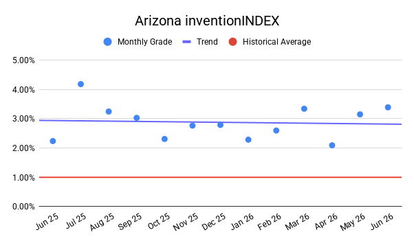
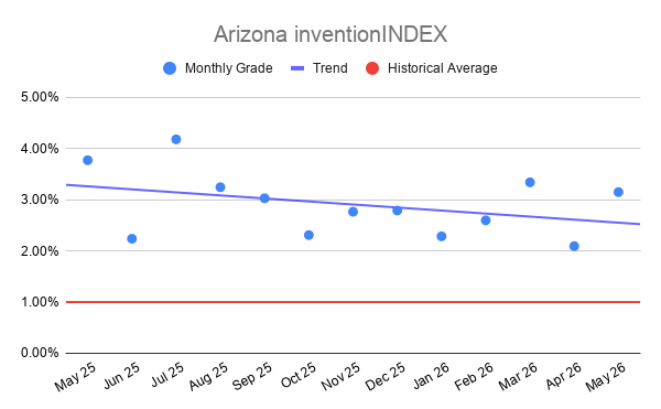
A manufacturing company in Phoenix that creates cylinders for the extraction and storage of different coolants and chemicals qualified for a substantial credit. The company claims R&D credits each year for the development activities of its engineers. This project involved a multi-year study.
The Company qualified for the federal R&D Tax Credits of $215,000 and an additional $258,000 in Arizona state R&D Tax Credits.
| FEDERAL | ARIZONA | |||||
| Year | Total QREs | Credit | Total QREs | Credit | ||
| 2026 | $650.000,00 | $65.000,00 | $650.000,00 | $78.000,00 | ||
| 2025 | $600.000,00 | $60.000,00 | $600.000,00 | $72.000,00 | ||
| 2024 | $550.000,00 | $55.000,00 | $550.000,00 | $66.000,00 | ||
| 2023 | $350.000,00 | $35.000,00 | $350.000,00 | $42.000,00 | ||
| Total | $2.150.000,00 | $215.000,00 | $2.150.000,00 | $258.000,00 | ||
Choose your state

Never miss a deadline again

Stay up to date on IRS processes

Discover R&D in your industry

Contact Us
Arizona Office
Phoenix, AZ 85050